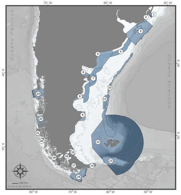
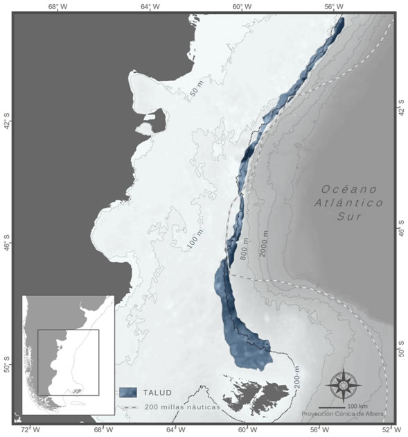
PATAGONIAN SEA LIGHTHOUSES . IDENTIFIED SITES
To date, 23 sites have been identified, of which 14 are in the South Atlantic, and the other 9 in the South Pacific.
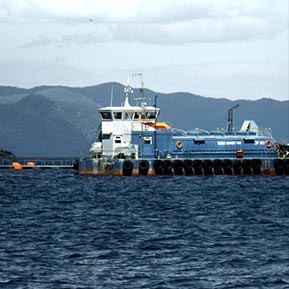
© J. Plana
All the Lighthouses
01. Región del Albardão, Brasil
02. Cerro Verde and Islas de la Coronilla
03. Río de la Plata Marine System
04. Magellanic Penguin Corridor
05. El Rincón Marine Coastal System
06. Gulfs of Northern Patagonia
07. Peninsula Valdes Oceanic Front
08. North of the Golfo San Jorge
09. Isla Pingüino
10. Shelf-break Front
11. Blue Hole
12. Malvinas / Falklands Ecoregion
13. Burdwood Bank
14. Staten Island and Beagle Channel
15. Bahía Lomas
16. Strait of Magellan
17. Seno Almirantazgo (Admiralty Sound)
18. Cabo de Hornos (Cape Horn)
19. Francisco Coloane
20. Isla Madre de Dios
21. Wellington Island Oceanic Front
22. Caleta Tortel
23. Golfo Corcovado – Isla Guafo
All the Lighthouses
All the Lighthouses
The majority of the lighthouses correspond exclusively to one country, one to Uruguay, eight to Argentina and nine to Chile. Two areas belong to two countries. Three areas of the South Atlantic include international waters. With reference to the degree of protection, seven are partially included in marine or coastal marine protected areas. In all the protected areas the implementation of conservation in the sea is incipient.
01. Región del Albardão, Brasil
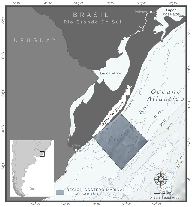
Región del Albardão, Brasil
The Albardão, in the extreme south of Brazil near the border with Uruguay, is
distinguished from the rest of the regional coastal-marine zone by presenting
consolidated sedimentary funds that contains the most important fossiliferous deposit
of the brazilian coast and attracts an amount of highly threatened marine species,
which have their feeding and breeding areas in this site.
Jurisdiction
Territorial Sea and Exclusive Economic Zone of Brazil.
Biogeographical Region
Temperate seas of South America. Temperate Southwestern Atlantic Province. Ecoregion of Rio Grande.
Types of Habitats
Sandy coastal platform with large extensions of consolidated funds containing Pleistocene fossil deposits.
Species Richness
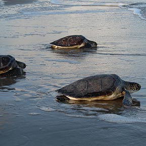
The region is part of the national biodiversity conservation priorities in Brazil due to its importance as a feeding and breeding area for vulnerable and threatened species, such as the Franciscana dolphin (Pontoporia blainvillei), marine turtles, elasmobranchs (Rhinobatos horkelii, Galeorhinus galeus, Squatina spp. And Sphyrna spp.), in addition to its value as the main fossiliferous deposit of the coast of Brazil, with frequent finds on the beach itself, of fossilized bones of Pleistocene mammals as well as fossil mollusk shells that cover the most extensive stretches of the coastal strip, locally called “concheiros”. Because of its isolation to the present, this coastal strip is an extremely important region for migratory birds.
Main Uses
Industrial fishery.
Threats
Industrial fishing inside the area and in the surroundings, which results in captures of highly threatened species.
Management – Main Government
Bodies Ministerio de Medio Ambiente – Instituto Chico Mendes de Conservación de la Biodiversidad (ICMBio); Instituto Brasilero de Medio Ambiente y Recursos Naturales Renovables (IBAMA).
Level of Protection
The region is under different restrictions for industrial fishing but these are not adequately controlled. The creation of a National Park has been proposed in 2008, and reiterated in 2015 by the Brazilian Congress of Protected Areas, but still not being effective.
© Arquivio NEMA
© Arquivio NEMA
© Arquivio NEMA
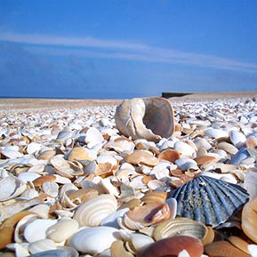
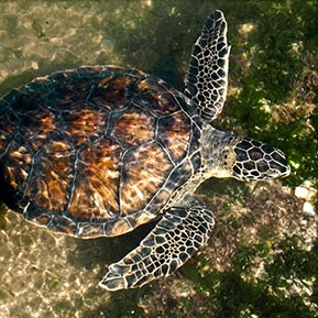
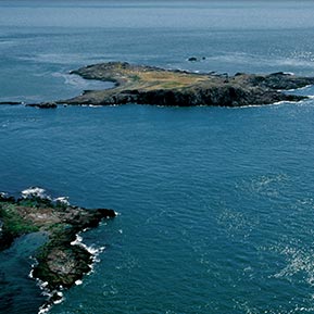
02. Cerro Verde and Islas de la Coronilla
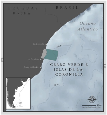
Cerro Verde and Islas de la Coronilla
Small islands of rocky outcrops that stretch into the sea off the Uruguayan coast. The area is relatively pristine, diverse regarding the composition of its communities and vital for ecological processes: it sustains high fish and invertebrate larvae concentrations, is an important foraging ground and growth site for green turtle individuals (a threatened species), and home to the only breeding colony of the royal tern on the Uruguayan coast.
Jurisdiction
Departamento de Rocha. Uruguayan Territorial Sea
Biogeographical Region
Temperate seas of South America. Warm Temperate Province of the Southwest Atlantic. Ecoregion: Uruguay – Buenos Aires Shelf.
Types of Habitats
Coastal environments, rocky capes, beach arcs, hills, lagoons, wetlands, swamps, marine coast and islands.
Species Richness
23 coastal and pelagic seabird species; 10 marine mammal species; 4 marine turtle species; 30 fish species; 130 marine invertebrate species reported.
Main Uses
Artisanal fishing and fishing for sport; tourism and recreational activities.
Threats
Negative impacts of some fishing activities on fish stocks (Argentine sea bass, sharks), marine mammals and turtles. Lack of regulation in local subsistence, artisanal and sport fishing. Illegal fishing vessels present.
Management – Main Government Bodies
Dirección Nacional de Recursos Acuáticos (DINARA). Sistema Nacional de áreas Protegidas (Uruguay).
Level of Protection
Since 2011 the site belongs to the “Área de manejo de hábitats y especies Cerro Verde” (“Cerro Verde Habitat and Species Management Area”) within the Sistema Nacional de áreas Protegidas (Ley N¡ 17.234) (National System for Protected Areas, Act Nº 17.234)
© A. Fallabrino
© virtualuruguay.com
© A. Fallabrino
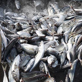
03. Río de la Plata Marine System
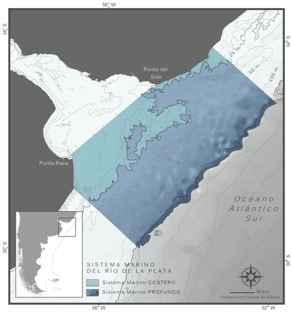
Río de la Plata Marine System
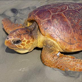
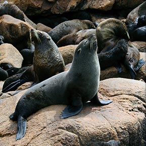
It consists of the Marine Coastal System associated with the saline front of the Rio de la Plata and the Deep Marine System associated with the shelf-break front. It features a great diversity of benthic invertebrates, spawning and breeding areas for targeted fishing species, and foraging areas for seabirds, marine turtles and mammals. More than 300.000 fur seals breed on Isla e islote de Lobos and Islas de Torres (Uruguay). Some of the species that make use of this system are threatened.
Jurisdiction
Argentine – Uruguayan Common Fishing Zone. Argentine Territorial Waters, Uruguayan Territorial Waters.
Biogeographical Region
Temperate seas of South America. Warm Temperate Province of the Southwest Atlantic. Ecoregion: Uruguay–Buenos Aires Shelf.
Types of Habitats
Benthic and pelagic shelf and shelf-break environments, saline Rio de la Plata front and thermohaline shelf-break front. Rocky coast and island environments (in Uruguay) and vast sandy beaches.
Species Richness
22 seabird species; 24 cetacean species; 2 pinniped species; 4 marine turtle species; 360 fish species; more than 570 marine invertebrates reported.
Main Uses
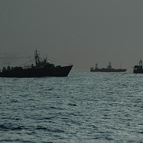
Coastal artisanal fishing and industrial fishing. The artisanal fleet catches whitemouth croaker, striped weak fish, Brazilian codling and sharks. Trawling targets hake, whitemouth croaker, and striped weak fish. On the shelf-break longline fisheries target tuna, swordfish and sharks. Intense tourist activity mainly in Punta del Este (Uruguay) and the seaside resorts of the Partido de la Costa and Pinamar (Argentina).
Threats
Overfishing. By-catch of cartilaginous fish, turtles, seabirds and marine mammals. Destruction of seabed communities. Liquid and solid waste from cities as well as vessels.
Management – Main Government Bodies
Argentine – Uruguayan binational bodies: Comisión Administradora del Río de la Plata (CARP), Comisión Técnica Mixta del Frente Marítimo (CTMFM). Argentina (Provincia de Buenos Aires): Organismo Provincial para el Desarrollo Sostenible (OPDS), Dirección de Pesca (Min. Asuntos Agrarios). Uruguay: Dirección Nacional de Recursos Acuáticos (DINARA), Sistema Nacional de Áreas Protegidas.
Level of Protection
There are some coastal areas with low level protection. Management measures include seasonal closure of fisheries and reserved areas for specific fisheries.
© D. Costa
© Leo Tamini AA–ATF
© I. Bruno
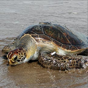
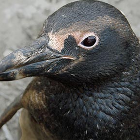
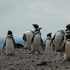
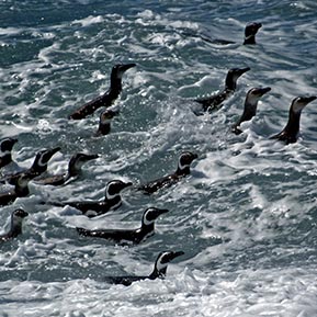
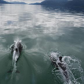
04. Magellanic Penguin Corridor
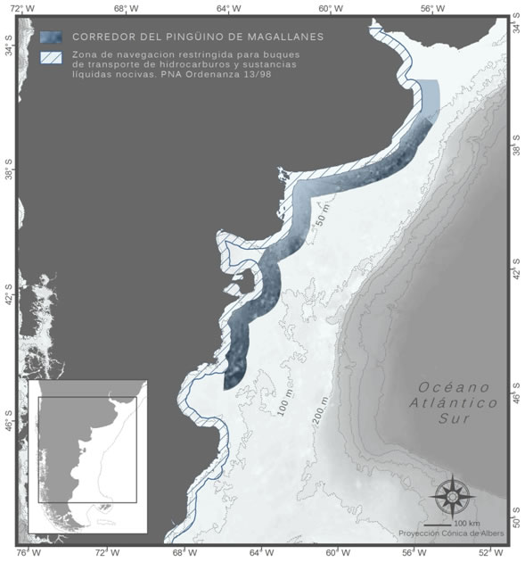
Magellanic Penguin Corridor
Está constituido por una franja marina que se extiende entre las 20 y las 40 millas náuticas siguiendo la línea de la costa argentina, desde la Provincia del Chubut hasta el Río de la Plata. La principal relevancia del área se basa en integrar parte de la ruta migratoria patagónica del pingüino de Magallanes. El corredor ha sido propuesto para minimizar la potencial interacción generada por el solapamiento entre la población migratoria de la especie y las rutas de transporte de hidrocarburos y navegación comercial.
Jurisdiction
Argentine – Uruguayan common fishing area and Argentine Exclusive Economic Zone.
Biogeographical Region
Temperate seas of South America. Magellanic Province. Ecoregion: North Patagonian Gulfs and the Uruguayan – Buenos Aires shelf.
Types of Habitats
Pelagic and benthic shelf environments.
Species Richness
There are no specific biodiversity studies for this area. Satellite monitoring surveys indicate that many seabirds and marine mammals use this area as a foraging ground.
Main Uses
Fisheries. Maritime transport, a proportion of which is associated with the oil and gas industry.
Management – Main Government Bodies
Binational Argentine-Uruguayan bodies: Comisión Técnica Mixta del Frente Marítimo (CTMFM). National Bodies: Prefectura Naval Argentina, Consejo Federal Pesquero, Subsecretaría de Pesca y Acuicultura, Secretaría de Ambiente y Desarrollo Sustentable (SAyDS)
Level of Protection
There are no marine protected areas in this sector. The proposed corridor crosses different fishing resource management areas.
© V. Ruoppolo
© G. Harris – WCS
© W. Conway
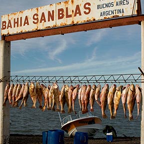
05. El Rincón Marine Coastal System
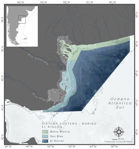
El Rincón Marine Coastal System
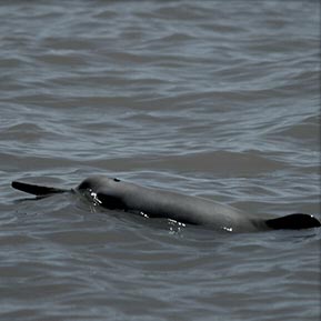
It encompasses the Bahía Blanca, Bahía San Blas coastal area and El Rincón marine area. The first two are rich in crustaceans and fish and are important for the breeding and development of the franciscana dolphin (a vulnerable species whose population is declining). On its coasts breeds 80% of Olrog’s gull (endemic species). El Rincón is an area where anchovy, prawns and shrimp can be found and is particularly rich in coastal fish of commercial interest belonging to the “variado costero” fish assemblage.
Jurisdiction
Argentine Territorial Waters and Argentine Exclusive Economic Zone
Biogeographical Region
Temperate seas of South America. Warm Temperate Province of the Southwest Atlantic. Ecoregion: Uruguay – Buenos Aires Shelf.
Types of Habitats
Coastal environments: wetlands, tidal swamps, tidal flats, marshes and sandy beaches. Pelagic and benthic shelf environments.
Species Richness
26 seabird species; 17 marine mammal species; 3 marine turtles; more than 30 fish species reported.
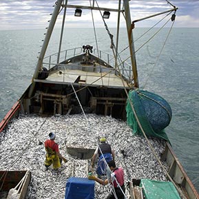
Main Uses
Artisanal fishing (significant in the Bahía Blanca coastal area), fishing for sport and industrial fishing (El Rincón area). Maritime transport and port activity.
Threats
By-catch of seabirds, marine mammals and turtles by the different fishing fleets that operate in the area. Dredging of navigable channels. Expansion of port and industrial areas.
Management – Main Government Bodies
Provincia de Buenos Aires: Organismo Provincial para el Desarrollo Sostenible (OPDS), Dirección de Pesca (Min. Asuntos Agrarios), Municipalidades de Bahía Blanca, Coronel Rosales, Villarino y Patagones. Provincia de Río Negro: Ministerio de Turismo, Secretaría de Medio Ambiente, Dirección de Pesca, Municipalidades de Viedma-El Cóndor. Organismos Nacionales: Consejo Federal Pesquero, Subsecretaría de Pesca y Acuicultura, Secretaría de Ambiente y Desarrollo Sustentable (SAyDS).
Level of protection
Protection of a land surface area of 1.100 km2 and marine surface area of 4.200 km2 by eight marine coastal areas, natural reserves and sanctuaries, (provincial and municipal) undergoing initial implementation. El Rincón is a protected area for the management of demersal species that make up the coastal fish assemblage called “variado costero”.
© Revista Puerto
© P. Bordino
© P. Bordino
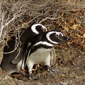
06. Gulfs of Northern Patagonia
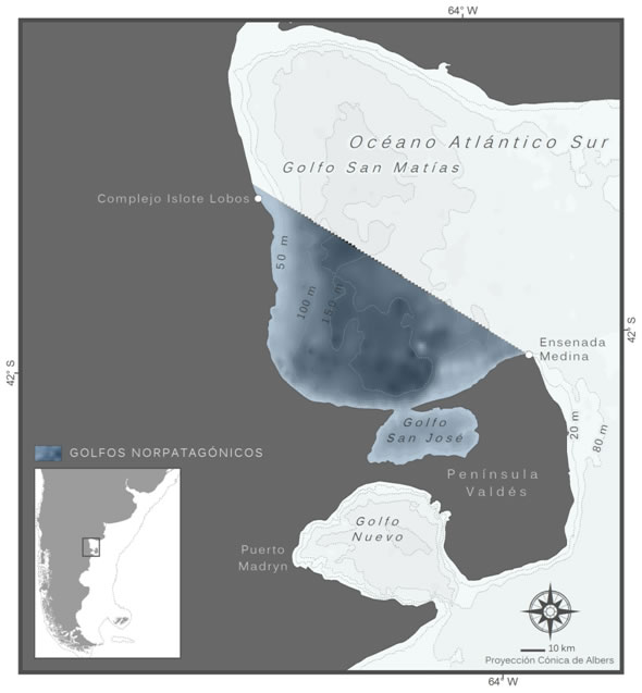
Gulfs of Northern Patagonia
Marine areas with a great diversity and abundance of benthic invertebrates, fish, seabirds and marine mammals. Restrictions on the dispersion of invertebrate larvae and fish have caused several species present in the Golfo San Matias to become populations independent from those in the Argentine Sea. The North Patagonian Gulfs are the main breeding ground for the southern right whale in the Southwest Atlantic. Its shores are home to the Magellanic penguin’s most northerly breeding colony. Species typically found in the warm Brazil current can be found in the Golfo San Matias, among them marine turtles.
Jurisdiction
Inshore waters of the provinces of Río Negro and Chubut.
Biogeographical Region
Temperate seas of South America. Magellanic Province. Ecoregion: North Patagonian: Gulfs.
Types of Habitats
Coastal environments: wetlands, sand or pebble beaches, wave-cut platforms, bays and high cliffs. Shallow subtidal environments with plenty of solar light penetration in the Golfo San Jose.
Species Richness
Seven species of seabirds and 2 pinniped species breed in the area. Twelve of the 37 marine mammal species reported in the area are resident. In the Golfo San Matías over 150 fish and invertebrate especies have been reported. In the Golfo San Jose, 69 invertebrate species.
Main Uses
Common hake industrial fishery and artisanal fishery for benthic invertebrates in the Golfo San Matias. Artisanal fishing for shellfish in the Golfo San Jose. Diving and fishing for sport. Maritime traffic. Scientific Research.
Threats
Overfishing; by-catch and incidental mortality of cartilaginous fish, seabirds and marine mammals; destruction of seabed communities by bottom trawling. Discharge of offal. Invasive alien species. Chronic contamination from hydrocarbons and oil spill accidents.
Management – Main Government Bodies
Provincia de Río Negro: Ministerio de Turismo, Ministerio de la Producción, Secretaría de Medio Ambiente y Dirección de Pesca. Provincia del Chubut: Ministerio de Ambiente y Control del Desarrollo Sustentable, Secretaría de Turismo y áreas Protegidas, Subsecretaría de Pesca, Dirección de Fauna y Flora Silvestre, Administración del área Natural Protegida Península Valdés.
Level of Protection
The Golfo San Jose is a provincial marine park which is a part of the Reserva Natural Turística de Objetivo Integral Península Valdés (Peninsula Valdes Nature and Tourist Reserve). There is a provincial fishing reseve as well as two coastal reserves for fauna in the sector of the Golfo San Matias that belongs to the Province of Rio Negro.
© Wikimedia–Commons
© L. Campagna
© S. Johnson – Quilimbai
07. Peninsula Valdes Oceanic Front
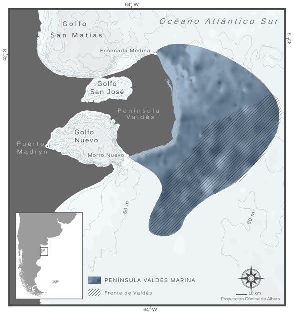
Peninsula Valdes Oceanic Front
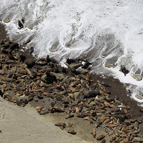
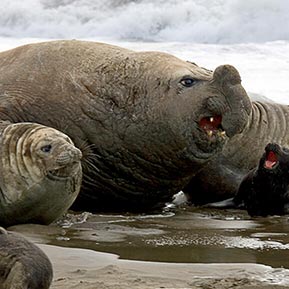
The Peninsula Valdes, a provincial natural area which has been declared a World Heritage Natural site, features unique landscapes and wonders of nature: the coast and surrounding waters are breeding and foraging sites for marine mammals and seabirds. The southern right whale and southern elephant seal are noteworthy species in the area. The marine area proposed as a “Lighthouse” includes the productive Valdes front in continental shelf waters.
Jurisdiction
Argentine Territorial Waters and Exclusive Economic Zone.
Biogeographic Region
Temperate seas of South America. Magellanic Province. Ecoregion: North Patagonian Gulfs.
Types of Habitats
Shoreline with cliffs and vast sand or pebble beaches. The pelagic and benthic shelf environments include productive and tidal fronts.
Species Richness
In the Peninsula Valdes area and its gulfs the following have been reported: 43 fish species; 73 waterfowl and seabird species (29 breed in the area); 37 marine mammal species (12 resident).
Main Uses
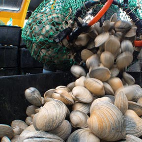
Wildlife watching tourism, seaside tourism, rural tourism, fishing for sport and diving. Cruise ship traffic, maritime transport and port activity. Artisanal fishing for bivalve molluscs and inshore fishing. Sand and gravel quarrying. Sheep raising up to the coast.
Threats
Overfishing; by-catch and incidental mortality of cartilaginous fish, seabirds and marine mammals; destruction of seabed comunities by bottom trawling. Discharge of offal. Chronic contamination from hydrocarbons and accidental oil spills.
Management – Main Government Bodies
Provincia del Chubut: Ministerio de Ambiente y Control del Desarrollo Sustentable, Secretaría de Turismo y Áreas Protegidas, Subsecretaría de Pesca, Dirección de Fauna y Flora Silvestre, Administración del Área Natural Protegida Península Valdés. Organismos nacionales: Consejo Federal Pesquero, Subsecretaría de Pesca y Acuicultura, Secretaría de Ambiente y Desarrollo Sustentable (SAyDS).
Level of protection
The Peninsula Valdes Protected Area with Managed Resources stretches from the shoreline up to 3 nautical miles around the peninsula.
© C. Campagna
© J. Large
© W. Conway
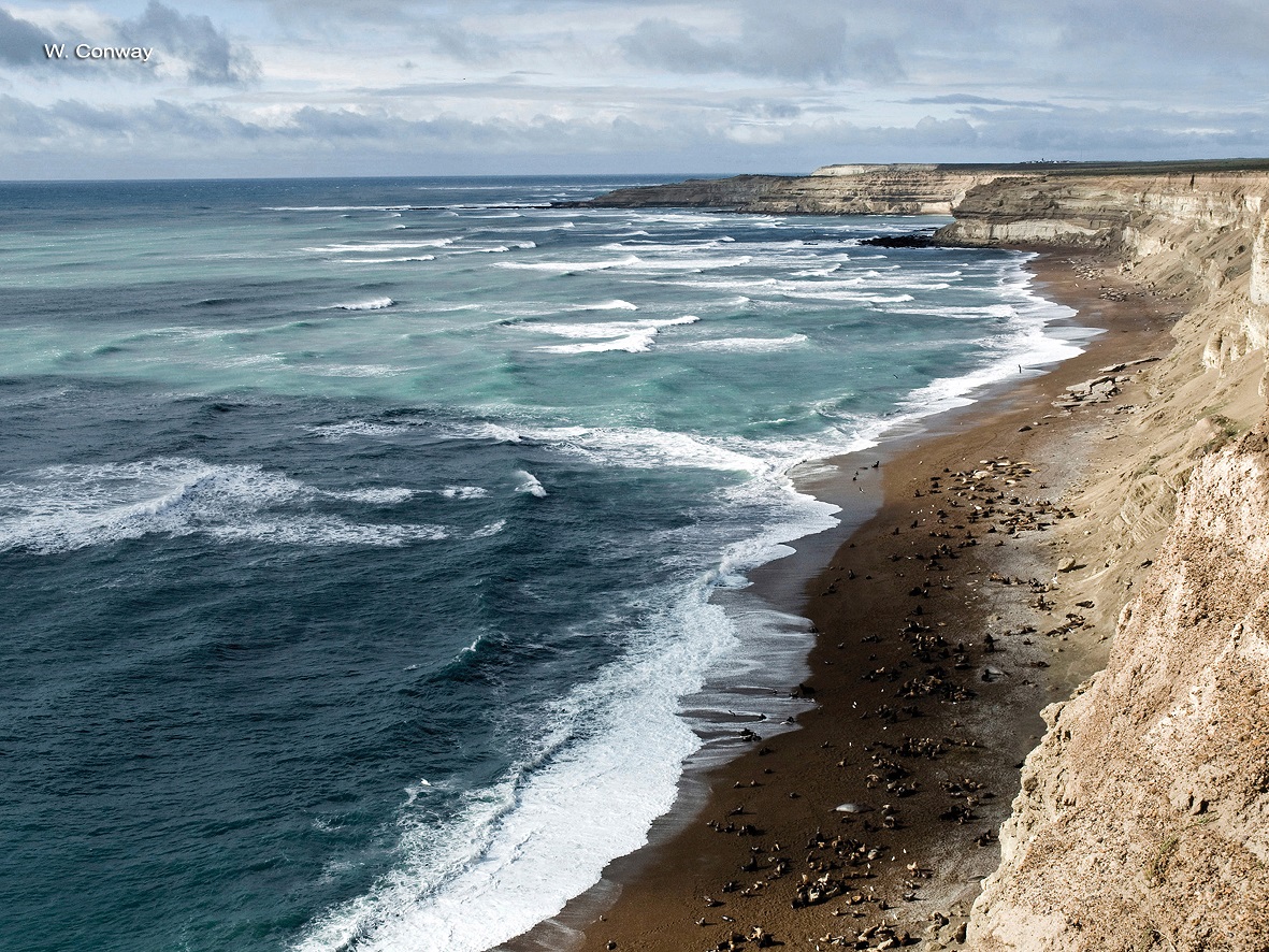
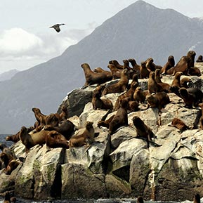
08. North of the Golfo San Jorge
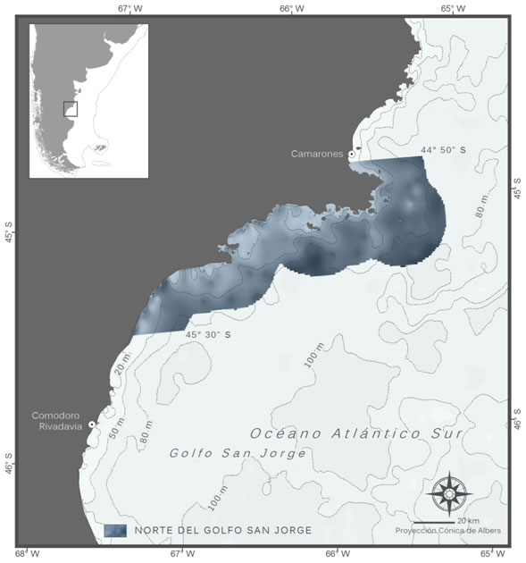
North of the Golfo San Jorge
It is an area of high productivity and great biodiversity in waters of the Province of Chubut. Thirteen of Argentina’s 16 resident seabird species breed in this area which is also home to the largest colony of the South American fur seal. Invertebrates and fish both spawn in the Golfo San Jorge and it is therefore important as a foraging area for seabirds and marine mammals.
Jurisdiction
Inshore waters of the Province of Chubut and Argentine Territorial Sea. The Parque Inter-jurisdiccional Marino Costero Patagonia Austral (Interjurisdictional Marine Coast Park of South Patagonia) Is located in this area.
Biogeographical Region
Temperate seas of South America. Magellanic Province. Ecoregion: North Patagonian Gulfs.
Types of Habitats
Coastal, pelagic and benthic shelf environments. It includes vast macroalgae blooms, rocky cliffs, islands big and small, bays and coves with sandy and rocky seabeds.
Species Richness
More than 40 species of bony and cartilaginous fish; 39 species of waterfowl and seabirds; 10 species of marine mammals.
Main Uses
Industrial fishing for common hake, inshore and artisanal fishing. It is the main area for red shrimp harvesting in Argentina. The Golfo San Jorge is one of the main areas for future development of the offshore oil industry in the country. Tourism related to nature is just starting in the area.
Threats
Chronic contamination from hydrocarbons and accidental oil spills. Overfishing; by-catch and incidental mortality of cartilaginous fish, seabirds and marine mammals; destruction of seabed communities by bottom trawling. Discards of by-catch to the sea and disposal of fishing waste in coastal garbage dumps. Invasive alien species.
Management – Main Government Bodies
Province of Chubut: Ministerio de Ambiente y Control del Desarrollo Sustentable, Secretaría de Turismo y çreas Protegidas, Subsecretaría de Pesca, Dirección de Fauna y Flora Silvestre. Organismos nacionales: Administración de Parques Nacionales (APN).
Level of Protection
The recently established and partially implemented Parque Inter-jurisdiccional Marino Costero Patagonia Austral (Interjurisdictional Marine Coast Park of South Patagonia) protects 790 km2 maritime space and 530 km2 of coastal area.
© V. Zavattieri
© L. Tamini AA–ATF
© Revista Puerto
09. Isla Pingüino
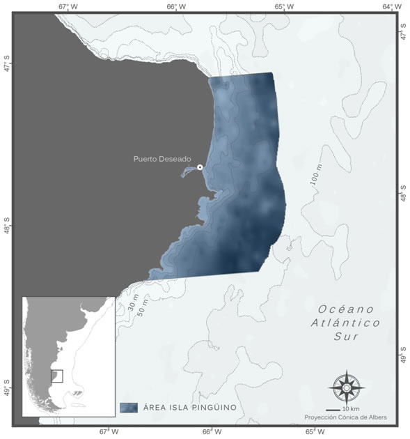
Isla Pingüino
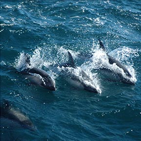
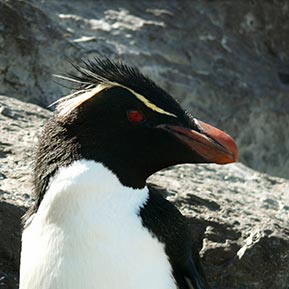
It comprises a coastal area and adjacent waters (up to 24 nautical miles) between Cabo Blanco and Bahía Laura, in the Province of Santa Cruz. Penguin Island (Isla Pinguino) is home to the only continental colony in South America of the Southern Rockhopper Penguin and a dozen Red-legged Cormorant colonies. Other species frequently found in the surrounding marine area is Commerson’s dolphin and Peale’s dolphin.
Jurisdiction
Argentine Territorial Sea and Exclusive Economic Zone. In this area is the Isla Pingüino Interjurisdictional Marine Park (Parque Inter-jurisdiccional Marino Isla Pingüino).
Biogeographical Region
Temperate seas of South America. Magellanic Province.
Ecoregion: Patagonian Shelf.
Types of Habitats
Coastal environments with gulches, rocky cliffs, ravines as well as sand and pebble beaches. Pelagic and benthic shelf environments that include productive and tidal fronts.
Species Richness
Eight marine mammal species; 50 waterfowl and seabird species; over 50 species of fish reported in this area.
Main Uses
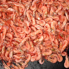
Industrial fishing for Argentine red shrimp and artisanal fisheries.
Threats
Chronic contamination from hydrocarbons and accidental oil spills. Overfishing; by-catch and incidental mortality of cartilaginous fish, seabirds and marine mammals; destruction of seabed communities by bottom trawling. Discards of non-target species and disposal of offal in dumps. Invasive alien species.
Management – Main Government Bodies
Province of Santa Cruz: Ministerio de la Producción, Consejo Agrario Provincial, Subsecretaría de Medio Ambiente, Subsecretaría de Pesca y Actividades Portuarias.
National Bodies: Administración de Parques Nacionales (APN).
Level of Protection
It contains four protected coastal areas, two of which provide marine environmental protection: the Reserva Natural Ría Deseado and the Parque Inter–Jurisdiccional Marino Isla Pingüino, (the latter was recently established and is undergoing implementaton) which respectively protect 100 km2 and 1.400 km2 of the sea.
© Leo Tamini AA–ATF
© Centro de Investigaciones Puerto Deseado UNPA
© J.P. Pereda
10. Shelf-break Front
Shelf-break Front
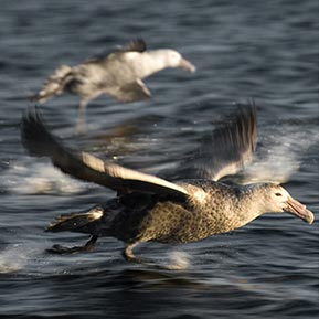
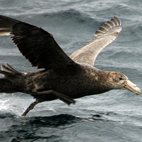
It is one of the vastest and most persistent oceanic fronts of the Patagonian Sea and has a key ecological and functional role for the Patagonian marine ecosystem. This highly productive area of the outer shelf that borders the shelf-break stretches more than 2,000 km. It sustains a complex trophic web including spawning areas for species of commercial value and it is the foraging ground and migratory path for top predators. At least seven threatened seabird species forage in this area.
Jurisdiction
Argentine Exclusive Economic Zone and high seas (international waters). The southern part of this area is controlled by the United Kingdom and is part of the area over which Argentina is claiming sovereignty.
Biogeographical Region
Temperate seas of South America. Magellanic Province. Ecoregion: Malvinas/Falklands, Patagonian Shelf and Urugay – Buenos Aires Shelf.
Types of Habitats
Shelf and shelf-break pelagic and benthic environments.
Species Richness
There is no specific description of the front with respect to its biodiversity. Varioius species of albatrosses, giant petrels, penguins and marine mammals forage in the area.
Threats
Unsustainable fishing activities, by-catch and discards of non-target species. Illegal, unreported, unregulated fishing.
Management – Main Government Bodies
Consejo Federal Pesquero, Subsecretaría de Pesca y Acuicultura; Ministerio de Relaciones Exteriores y Culto; Secretaría de Ambiente y Desarrollo Sustentable (SAyDS).
Level of Protection
There are no marine protected areas in this sector. Management measures are applied for harvesting the Argentine squid, there is a special zone for freezer trawlers as welll as management areas and temporary no-take zones during the scallop breeding season.
© V. Falabella
© V. Zavattieri
© Wikimedia–Commons
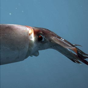
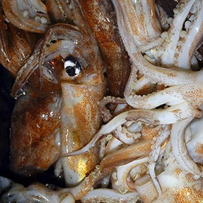
11. Blue Hole
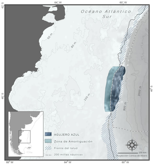
Blue Hole
The Blue Hole is an area outside the Patagonian continental shelf located beyond Argentina’s Exclusive Economic Zone some 500 km east of the Golfo San Jorge. It belongs to the shelf-break oceanic front and is noteworthy for being in the migratory path of the Argentine squid. It is a foraging ground for seabirds and marine mammals.
Jurisdiction
International waters (high seas) in a sector of the continental shelf of Argentina outside its Exclusive Economic Zone. The adjacent buffer zone does belong to Argentina’s Exclusive Economic Zone.
Biogeographical Region
Temperate seas of South America. Magellanic Province. Ecoregion: Patagonian Shelf.
Surface
The Blue Hole (Agujero Azul): 6.600 km2
Buffer zone: 7.160 km2
Types of Habitats
Shelf and shelf-break pelagic and benthic environments.
Species Richness
There are no specific studies for this sector. We can infer that it is highly productive from regional fisheries and scientific knowledge (satellite monitoring) of seabird and marine mammal migratory paths and foraging grounds.
Main Uses
Intensive fishing for the Argentine squid (Illex argentinus) and demersal fish by long distance trawlers (specially Spanish).
Threats
Illegal, unreported unregulated fishing. Destruction of seabed communities by trawling.
Management – Main Government Bodies
Ministerio de Relaciones Exteriores y Culto ; Consejo Federal Pesquero, Subsecretaría de Pesca y Acuicultura; Secretaría de Ambiente y Desarrollo Sustentable (SAyDS)
Level of Protection
The buffer zone is in a special fishing area for freezer trawlers.
© J. González Solís
© M. Brunella – FVSA
© C. Verona
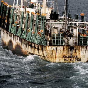
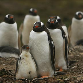
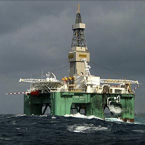
12. Malvinas / Falklands Ecoregion
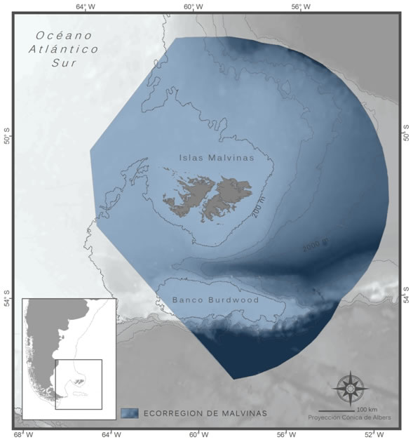
Malvinas / Falklands Ecoregion
The Falkland Islands (Malvinas) archipelago, in the southwest of the South Atlantic Ocean, is situated some 530 kilometres east of Bahía Grande, Province of Santa Cruz (Argentina). The area’s productivity is evidenced by the great variety of fish, invertebrates and algae. On its shores breed 22 species of seabirds (three of them globaly threatened) and three species of pinnipeds. 74% (approximately 380.000 pairs) of the world population of Black-browed Albatross breeds on the islands. Surrounding waters are frequently visited by more than 20 species of cetaceans (of which 11 are globally threatened).
Biogeographical Region
Temperate seas of South America. Magellanic Province. Ecoregion: Malvinas / Falklands.
Types of Habitats
Coastal environments with tussock grass (Poa flabellata). Intertidal habitats include marshes, rocky shores and sand as well as pebble beaches. 18 marine habitats have been desribed based on predominant substrata and the assemblage of organisms living therein.
Species Richness
22 seabird species breed in the area; 3 pinniped species and more than 20 cetaceans frequently visit the surrounding waters. More than 550 marine species have been reported counting fish, invertebrates and algae.
Main Use
Commercial fishing. Hydrocarbon exploration and drilling. Agriculture. Tourism.
Threats
Hydrocarbon contamination events. Lack of regional cooperation in fisheries management.
Management- Main Government Bodies
A dispute exists between the Governments of Argentina and the United Kingdom of Great Britain and Northern Ireland concerning sovereignty over the Falkland Islands (Malvinas)
Level of Protection
Various reserves on land protect the main seabird breeding sites. Various management/conservation areas have been established protecting specific marine areas.
© V. Falabella
© MercoPress
© SMSG
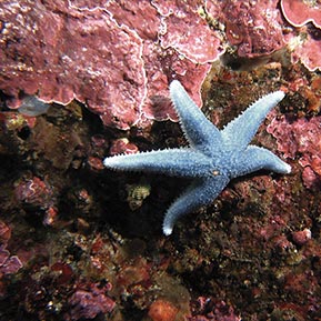
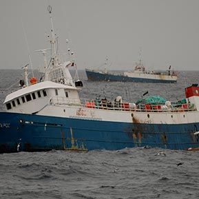
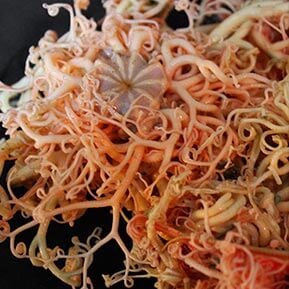
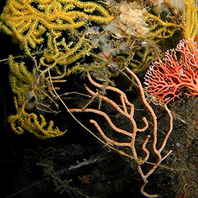
13. Burdwood Bank
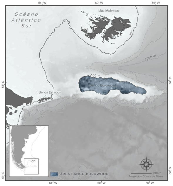
Burdwood Bank
An undersea plateau with a maximum depth of 200 metres, situated approximately 150 km east of the Isla de los Estados (Staten Island) and about 160 km south of the Falkland Islands (Malvinas) archipelago. Noteworthy are seabed fauna assemblages which include endemic species. Fish of commercial value, such as southern blue whiting, Patagonian toothfish, and Falkland sprat breed in waters that surround the bank.
Biogeographical Region
Temperate seas of South America. Magellanic Province. Ecoregion: Malvinas / Falklands.
Typs of Habitats
Undersea plateau. Oceanic and shelf pelagic and benthic environments.
Species Richness
Outstanding richness of benthic invertebrates, (some of them reported as endemic and vulnerable species) among them crustaceans, molluscs, 60 cold water coral species, hydrocorals, cnidaria and 30 sponge species. At least 18 seabird and marine mammal species forage or migrate in the area.
Main Uses
Some industrial fishing for Patagonian toothfish. Area of interest for the potential of its undersea oil fields.
Threats
Real direct threats are unknown. Ultimately, the start up of bottom trawling and oil drilling activites affecting the seabed and subsoil may have considerable impact on benthic communities.
Level of Protection
This area includes the “Namuncurá – Burdwood Bank” Marine Protected Area. There is a zone of 1,800 km2 totally and permanently closed to fishing.
© G. Robertson
© L. Schejter
© D.G. Nicholls
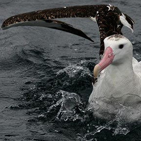
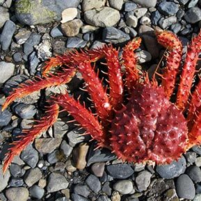
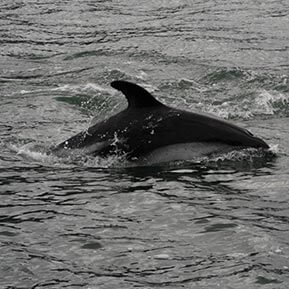
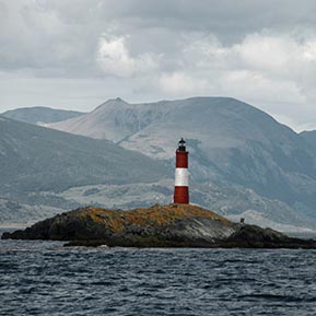
14. Staten Island and Beagle Channel
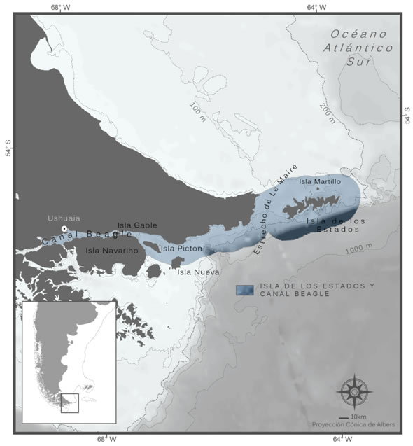
Isla de los Estados (Staten Island) and Beagle Channel
This Argentine-Chilean binational site is located in the southern boundary of the Isla Grande de Tierra del Fuego, and includes Isla de los Estados (Staten Island), Mitre Peninsula, the Le Maire Strait and the eastern part of the Beagle Channel. The area is home to the only Magellanic penguin colony known in the channel as well as to the only Gentoo penguin colony reported in South America. Isla de los Estados (Staten Island) is the main breeding site for the southern rockhopper penguin (26% of the world population of this subspecies).
Jurisdiction
Argentine Territorial Sea, Province of Tierra del Fuego, Antarctica and South Atlantic Islands. Chilean Territorial Sea, Chilean Antarctica and Magellan Region (Región de Magallanes y Antártica Chilena).
Biogeographical Region
Temperate seas of South America. Magellanic Province. Ecoregion: Channels y Fjords of South Chile.
Types of Habitats
Irregular coastal environments with coves, closed bays, fjords, and brown algae beds. Island, pelagic and benthic shelf environments.
Species Richness
Six marine mammal species; 20 waterfowl and seabird species; and about 40 species of bony and cartilaginous fish.
Main Uses
It has the main port of the Isla Grande de Tierra del Fuego (Ushuaia) and one dock for unloading refined fuels. Intense traffic of transport, industrial fishing and tourist vessels. Artisanal fishing for king crab and false southern king crab. Small scale mussel harvesting along the coast.
Threats
Lack of coordination in the managment of artisanal fishing. Discharge of offal from fishing vessels and trash on the beaches. Anthropic impact and eutrophication in coastal areas near Ushuaia. Invasive alien species. Maritime traffic.
Management – Main Government Bodies
Argentina: Ministerio de Relaciones Exteriores y Culto, Secretaría de Ambiente y Desarrollo Sustentable (SAyDS), Administración de Parques Nacionales, Secretaría de Desarrollo Sustentable y Ambiente de la Provincia de Tierra del Fuego, Antártida e Islas del Atlántico Sur. Chile: Ministerio del Medio Ambiente, Servicio Nacional de Pesca (SERNAPESCA), Subsecretaría de Pesca (SUBPESCA), Dirección General del Territorio Marítimo y de Marina Mercante (DIRECTEMAR), Armada de Chile, Gobierno Regional (GORE), Ilustre Municipalidad de Cabo de Hornos.
Level of Protection
There are three protected coastal areas in Argentina (not protecting marine environments): Tierra del Fuego National Park, Reserva Playa Larga and Reserva Isla de los Estados, Islas de Año Nuevo e Islotes Adyacentes, the latter having significant usage restrictions.
© Wikimedia–Commons
© C. Briceño
© A. Raya Rey
15. Bahía Lomas
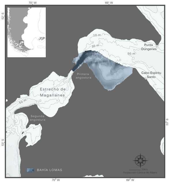
Bahía Lomas
It is located at the beginning of the Strait of Magellan on the southern shore, stretching from the east mouth to the Primera Angostura. It includes sandy beaches such as those at Lomas and Orange, and represents 75% of all relevant beaches and wetlands for shorebirds in southern Chile. It is also important as a habitat for endemic or restricted range invertebrates.
Jurisdiction
Chilean Territorial Sea, Chilean Antarctica and Magellan Region (Región de Magallanes y Ant‡rtica Chilena), Province of Tierra del Fuego, Comuna de Primavera.
Biogeographical Region
Temperate seas of South America. Magellanic Province.
Ecoregion: Channels and Fjords of southern Chile.
Types of Habitats
Coasts with wetlands, sandy beaches and brown algae beds (Macrocystis pyrifera), relevant as refuges for benthic species in their larval state. Unstable habitats due to strong tidal currents.
Wealth of species
Ten marine mammal species; 25 waterfowl and seabird species.
Main Uses
Artisanal and commercial fisheries. Tourism. Area of intensive navigation. Oil exploration and drilling.
Threats
Chronic contamination related to maritime traffic (fuels, ballast waters). Oil spillls.
Management – Main Government Bodies
Ministerio del Medio Ambiente, Dirección General del Territorio Marítimo y Marina Mercante (DIRECTEMAR), Subsecretaría de Pesca (SUBPESCA), Servicio Nacional de Pesca (SERNAPESCA), Municipalidad de Primavera.
Level of Protection
No marine protected areas. Bahía Lomas was declared Ramsar site.
© Wikimedia–Commons
© S. Cornejo
© C. Silva–Quintas
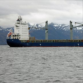
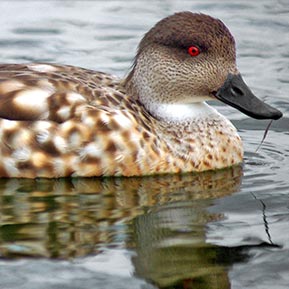
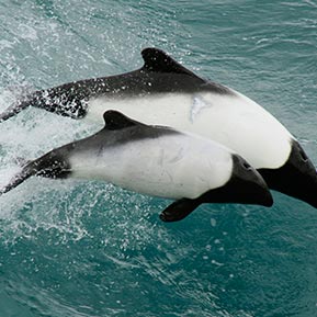
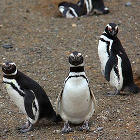
16. Strait of Magellan
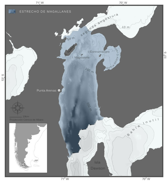
Strait of Magellan
This Strait of Magellan sector, where the waters of the Pacific and Atlantic Oceans converge, stretches from Segunda Angostura to Fuerte Bulnes in Chile. There are two Magellanic penguin colonies on its shores. The strait is important for the conservation of marine mammals resident in the area and is a potential migratory path for the southern right whale and other species.
Jurisdiction
Chilean Territorial Sea, Chilean Antarctica and Magellan Region (Región de Magallanes y Antártica Chilena), Provinces of Tierra del Fuego and Magallanes. Comunas of Punta Arenas, Porvenir, Primavera and San Gregorio.
Biogeographical Region
Temperate seas of South America. Magellanic Province. Ecoregion: Channels and Fjords of southern Chile.
Types of Habitats
The coasts of the strait features bays, islands and rocky cliffs. The brown algae beds (Macrocystis pyrifera and Lessonia nigrescens) are important habitats for benthic invertebrates.
Species Richness
Ten marine mammal species; 25 waterfowl and seabird species.
Main uses
Intensive artisanal fishing. Commercial fishing and tourism. As a navigation route the strait is very important, both commercially and strategically.
Threats
Chronic contamination related to maritime traffic (fuels, ballast waters). Oil spills. Contamination from clandestine coastal dumps. Risk of vessels colliding with cetaceans.
Management – Main Government Bodies
Ministerio del Medio Ambiente, Dirección General del Territorio Marítimo y Marina Mercante (DIRECTEMAR), Subsecretaría de Pesca (SUBPESCA), Servicio Nacional de Pesca (SERNAPESCA), Gobernaciones de las Provincias de Magallanes y Tierra del Fuego, Municipalidad de Punta Arenas, CONAF (administration of Los Pingüinos Natural Monument).
Level of Protection
There are no marine protected areas.
© R. Muza
© T. Tok
© S. Cornejo
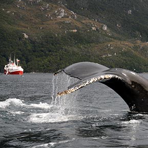
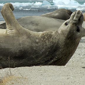
17. Seno Almirantazgo (Admiralty Sound)
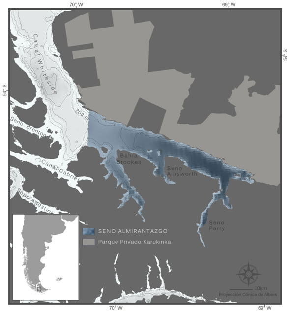
Seno Almirantazgo (Admiralty Sound)
Admiralty Sound is a large fjord in the Chilean part of Tierra del Fuego. It is noteworthy for the black browed albatross breeding colony in its inshore waters, which makes it unique in the world. A small breeding group of elephant seals have also been found, unique in Chilean inshore waters.
Jurisdiction
Chilean Territorial Sea, Chilean Antarctica and Magellan Region (Región de Magallanes y Antártica Chilena), Province of Tierra del Fuego, Comuna Timaukel.
Biogeographicl Region
Temperate seas of South America. Magellanic Province. Ecoregion: Channels and Fjords of southern Chile.
Types of Habitats
Coastal environments of fjords and glaciers, bays, channels and islands. Depth of the water in the sound ranges between 50-100 metres.
Wealth of species
15 marine mammal species; 72 waterfowl and seabird species.
Main Uses
Artisanal fishery for invertebrates. Tourism. Scientific research.
Threats
Solid waste on the shores from artisanal fisheries and aquaculture. Overfishing of invertebrates. Unregulated tourism.
Management – Main Government Bodies
Ministerio del Medio Ambiente, Autoridades de la Región de Magallanes y Antártica Chilena, CONAF (Alberto De Agostini National Park Administration), Servicio Nacional de Turismo (SERNATUR), Servicio Nacional de Pesca (SERNAPESCA), Armada de Chile.
Level of Protection
The Sound is bordered by two continental parks: the Karukinka Private Park (administrated by the Wildlife Conservation Society) to the north and the Alberto De Agostini National Park on the southern shore.
© G. Harris – WCS
© G. Harris – WCS
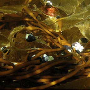
© J. Plana
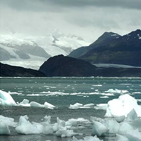
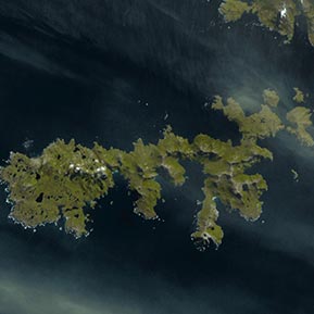
18. Cabo de Hornos (Cape Horn)
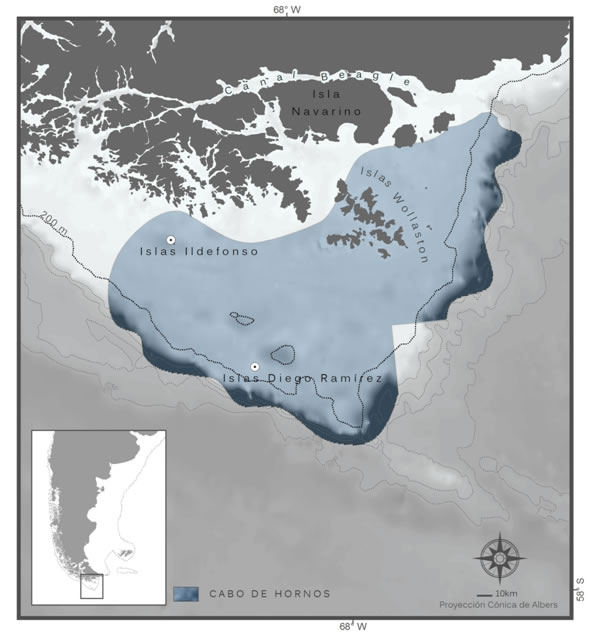
Cabo de Hornos (Cape Horn)
It comprises Wollaston, Ildefonso, Terhalten and Diego Ramírez Islands, and the surrounding oceanic area. These islands are noteworthy as breeding sites for seabirds and marine mammals and are within the boundaries of the Cape Horn Biosphere Reserve. (Reserva de la Biósfera Cabo de Hornos). The confluence of water masses important for regulating global climate, such as the sub-surface Antarctic waters and the West Wind Drift waters, takes place in this region.
Jurisdiction
Chilean Territorial Sea and Exclusive Economic Zone. Chilean Antarctic and Magellan Region (Region de Magallanes y Antartica Chilena), Chilean Antarctic Province, Comuna de Cabo de Hornos.
Biogeographical Region
Temperate seas of South America. Magellanic Province. Ecoregion: Channels and Fjords of Southern Chile.
Types of Habitats
Heterogenous islands and coastal areas exposed to different oceanographic regimes. Pelagic and benthic marine shelf and shelf-break environments. Brown algae beds and belts.
Species Richness
28 marine mammal species; 74 waterfowl and seabird species.
Main Uses
Artisanal fishing for invertebrates and industrial fishing for Patagonian toothfish, Patagonian grenadier and southern blue whiting. The salmon farming industry has shown potential interest in moving into the area.
Threats
No direct real threats are known. Potential impacts of industrial fishing and unregulated tourism have not been evaluated.
Management – Main Government Bodies
Ministerio del Medio Ambiente, Subsecretaría de Pesca (SUBPESCA), Servicio Nacional de Pesca (SERNAPESCA), Dirección General del Territorio Marítimo y de Marina Mercante (DIRECTEMAR), Armada de Chile, Ministerio de Bienes Nacionales, Corporación Nacional Forestal (CONAF), Gobernación Provincial Ant‡rtica Chilena, Ilustre Municipalidad de Cabo de Hornos.
Level of Protection
The Cape Horn National Park and Cape Horn Biosphere Reserve (Parque Nacional Cabo de Hornos y la Reserva Biósfera de Cabo de Hornos) do not encompass marine environments.
© R. Muza
© earthobservatory.nasa.gov
© C. Silva–Quintas
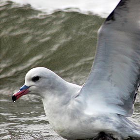
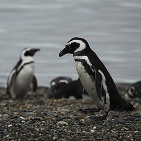
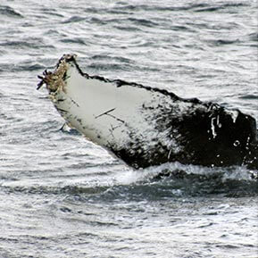
19. Francisco Coloane
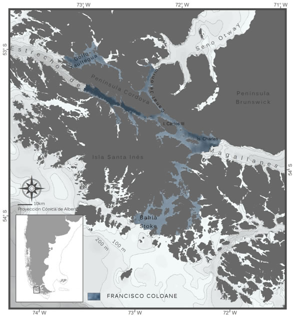
Francisco Coloane
The first Coastal Marine Protected Area established in Chile, located at the western end of the Strait of Magellan. It is a breeding site and foraging ground for the humpback whale and a natural habitat for other cetaceans such as Sei whales (vulnerable species), Minke whales, and killer whales. There are sea lion colonies on its shores, as well as breeding sites of penguins and other seabirds. As in other southern areas, of Chile there are sea otters (endangered).
Jurisdiction
Chilean Territorial Sea, Chilean Antarctica and Magellan Region (Región de Magallanes y Antártica Chilena), Province of Magallanes, comunas of Punta Arenas and Río Verde.
Biogeographical Region
Temperate seas of South America. Magellanic Province.
Ecoregion: Channels and Fjords of southern Chile.
Types of Habitats
Coastal environments of fjords, glaciers, bays, channels and islands. In the undersea environments: rocky and coral reefs and brown algae beds.
Wealth of species
Nine marine mammal species; 32 waterfowl and seabird species.
Main Uses
Artisanal fishing. Navigation. Tourism and scientific research. The Golfo Xaultegua was defined as an area appropriate for aquaculture and many applications for this activity have been submitted.
Threats
Unregulated fishing and tourism. Rubbish dumps.
Management – Main Government Bodies
Ministerio del Medio Ambiente, Subsecretaría de Pesca (SUBPESCA), Servicio Nacional de Pesca (SERNAPESCA), Dirección General del Territorio Marítimo y de Marina Mercante (DIRECTEMAR), CONAF (administración del Parque Nacional Alberto De Agostini), authorities of the Región de Magallanes y Antártica Chilena, authorities of the towns of Punta Arenas and Río Verde.
Level of protection
The Francisco Coloane Coastal Marine Protected Area was established in 2003 covering 760 km2.
© Wikimedia–Commons
© R. Muza
© Hucke–Gaete UACh–CBA
20. Isla Madre de Dios
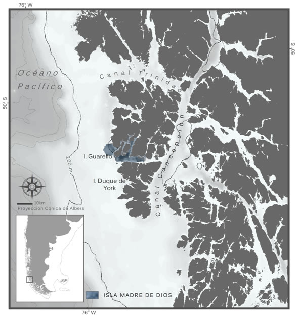
Isla Madre de Dios
This island in southern Chile, while exceptional for its geology, paleontology and ethnografic significance, is surrounded by a marine environment with hydrocorals (Hydrozoa: Stylasteridae) and cold water coral reefs. This area also features a high concentration of sea lions and South American fur seals in breeding colonies and places where they rest.
Jurisdiction
Chilean Territorial Sea, Chilean Antarctica and Magellan Region (Región de Magallanes y Ant‡rtica Chilena), Province of Última Esperanza, comuna of Puerto Natales.
Biographic Region
Temperate seas of South America. Magellanic Province.
Ecorregion: Channels and Fjords of southern Chile.
Types of Habitats
Irregular coastal environments, fjords, channels and coral reefs. Along the open shores: intertidal belts with algae beds. (Durvillea antartica, Lessonia nigrescens y Macrocystis pyrifera).
Wealth of species
Ten marine mammal species; 6 coastal and pelagic seabird species. Great diversity of benthic invertebrates, algae, hydrocoral and cold water coral reefs.
Main Uses
The area has been declared available for tourism and fishing by the Macrozonificación de Borde Costero (Shoreline Macrozoning) initiative. Currently the main activities are: artisanal and commercial fishing, ecotourism and research.
Threats
Unregulated tourism. Interaction between fisheries and marine mammals (by-catch, entanglements in fishing gear). Increase in coral extraction for sale as tourist souvenirs.
Management – Main Government Bodies
Ministerio del Medio Ambiente, Ministerio de Bienes Nacionales, Dirección General del Territorio Marítimo y de Marina Mercante (DIRECTEMAR), Subsecretaría de Pesca (SUBPESCA), Servicio Nacional de Pesca (SERNAPESCA), Corporación Nacional Forestal (CONAF), Municipalidad de Puerto Natales, Gobernación de Última Esperanza y Capitanía de Puerto (Puerto Edén).
Level of Protection
There are no marine protected areas in this sector.
© Wikimedia–Commons
© diario.latercera.com
© D. Schories – guiamarina
21. Wellington Island Oceanic Front
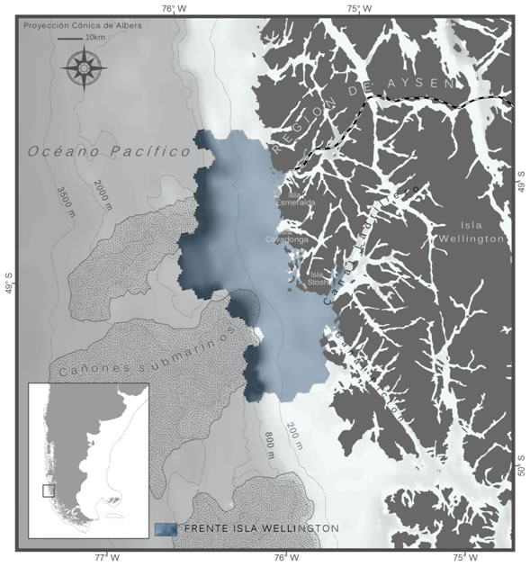
Wellington Island Oceanic Front
This oceanic front, west of the Ladrillero channel and the Wellington, Esmeralda, Covadonga and Stosh islands, comprises a shelf and shelf-break area where undersea canyons start in the seabed. It is important as a spawning ground for the southern blue whiting and also owing to the presence of hydrocorals and cold water corals and to the significant concentration of South American sea lions and fur seals on its shores.
Jurisdiction
Chilean Territorial Sea, Chilean Antarctic and Magellan Region (Región de Magallanes y Ant‡rtica de Chile), Province of última Esperanza, comuna of Puerto Natales.
Biogeographical Region
Temperate seas of South America. Magellanic Province. Ecoregion: Channels and Fjords of Southern Chile.
Types of Habitats
Heterogeneous coastal environment exposed to oceanic effects, with channels, fjords and intertidal brown algae belts. Nerithic and oceanic pelagic environment.
Wealth of species
There is no description of the area’s biodiversity. Two pinniped species and 2 penguin species breed here.
Main Uses
Artisanal and industrial fishing. Navigation. Tourism. Aquaculture.
Threats
Potential development of aquaculture in the area. Risk of contamination from oil spills due to the proximity of navigation routes.
Management – Main Government Bodies
Ministerio del Medio Ambiente, Ministerio de Bienes Nacionales, Dirección General del Territorio Marítimo y de Marina Mercante (DIRECTEMAR), Subsecretaría de Pesca (SUBPESCA), Servicio Nacional de Pesca (SERNAPESCA), Corporación Nacional Forestal (CONAF), Municipalidad de Puerto Natales, Gobernación de Ultima Esperanza y Capitanía de Puerto (Puerto Edén).
Level of Protection
No marine protected areas in this sector.
© Wikimedia–Commons
© E. Sorensen
© M. Stenzel – NGS
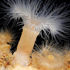
22. Caleta Tortel
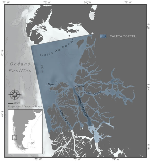
Caleta Tortel
This site comprises the waters and fjords of the comuna Tortel in Chile. To the southwest the area includes islands of the Bernardo O’Higgins National Park. There is a diversity of benthic invertebrates, particularly sponges and hydrocorals for which various endemisms have been described. The high productivity of its waters favours the development of fish and invertebrate larvae.
Jurisdiction
Chilean Territorial Sea, Aysén del General Carlos Ib‡–ez del Campo Region, Province of Capit‡n Prat, comuna Tortel.
Biogeographical Region
Temperate seas of South America. Magellanic Province.
Ecorregion: Channels and Fjords of southern Chile.
Types of Habitats
Rocky coasts. Benthic and pelagic shelf environments, macroalgae beds, coral reefs and mussel beds.
Species Richness
Six marine mammal species; 17 seabird species and 25 coast and landbirds. Surveys undertaken in 10% of the total surface area identified: 13 fish species; 132 benthic invertebrate species; 6 macroalgae.
Main Uses
Artisanal invertebrate fishery. Industrial Patagonian grenadier fishery, which uses bottom trawl nets, in the northern part of this area. Potential aquaculture development, particularly salmon farming.
Threats
Should it materialize in the future, intensive salmon farming (alien species) may impact the environment due to excessive nutrients, use of antibiotics and other contaminating substances.
Management – Main Government Bodies
Ministerio del Medio Ambiente, Ministerio de Bienes Nacionales, Dirección General del Territorio Marítimo y de Marina Mercante (DIRECTEMAR), Servicio Nacional de Pesca (SERNAPESCA), Corporación Nacional Forestal (CONAF), comuna Tortel, Provincia de Capit‡n Prat e Intendencia de la Región Aysén.
Level of Protection
There are no marine protected areas. The establishment of the Tortel Marine Coastal Protected Area for Multiple Uses is currently being evaluated.
© E. Sorensen
© C. Gutierrez
© E. Sorensen
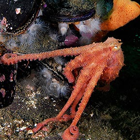
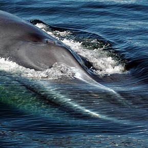
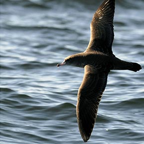
23. Golfo Corcovado – Isla Guafo
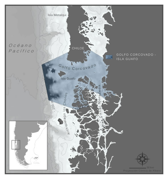
Golfo Corcovado – Isla Guafo
The Golfo Corcovado and Guafo mouth area is located south of the big Chiloe island in Chile. It is an important area for marine mammals, including threatened species. It is noteworthy as the breeding site and foraging ground of a recently discovered blue whale population. This area is home to the largest sooty shearwater colony in the world.
Jurisdiction
Chilean Territorial Sea, Región de Aysén del General Carlos Ibáñez del Campo and Región de los Lagos, Provinces of Aysén, Palena and Chiloé.
Biogeographical Region
Temperate seas of South America. Magellanic Province. Ecoregion: Chiloense.
Types of Habitats
Coastal environments of sand and rocky beaches, fjords, channels and islands. Pelagic, demersal and benthic shelf environments. Beds of cold water sponges and coral reefs.
Species Richness
Over 700 marine invertebrate species; 410 bony fish and 30 cartilaginous fish species; 31 marine mammal species (cetaceans and pinnipeds) and 2 otter species; 110 bird species; 12 algae species.
Main Uses
Artisanal fishery for invertebrates and fish. Industrial fishery for hake and Patagonian grenadier. Intensive salmon and mollusc farming. Navigation and maritime transport. Scientific research. Tourism.
Threats
Impacts associated with aquaculture: eutrophication, excessive use of antibiotics, discharge of dead salmon, inappropriate waste treatment, illegal sea lion hunting, cetacean and bird entangling in fishing gear. Maritime traffic. Overfishing for anchovy, hake and benthic resources (sea urchins and algae).
Management – Main Government Bodies
Ministerio del Medio Ambiente, Ministerio de Bienes Nacionales, Dirección General del Territorio Marítimo y de Marina Mercante (DIRECTEMAR), Subsecretaría de Pesca (SUBPESCA), Servicio Nacional de Pesca (SERNAPESCA), Corporación Nacional Forestal (CONAF), Autoridad Marítima competente de la respectiva Zona Naval, Regiones de Los Lagos y de Aysén: Intendencias and Consejos Regionales.
Level of Protection
No marine protected areas in this sector. Currently the World Wildlife Fund (WWF) and the Centro Ballena Azul advocate the establishment of a Coastal Marine Protected Area for Multiple Uses.
Fishing regulations for resources of commercial interest are in place.
© Hucke–Gaete UACh–CBA
© Hucke–Gaete UACh–CBA
© Hucke–Gaete UACh–CBA